
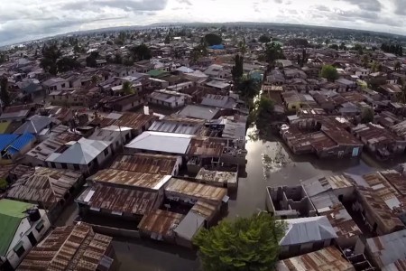
Everyone is impacted by the effects of flooding in Dar. A community mapping project is using data and drones to promote flood resilience. Photo: Mark Iliffe cc-by sa 4.0
When it rains in Dar, it floods.
And when it floods everyone is impacted: the transportation network grinds to a halt, infrastructure fails and the economy suffers.
Armed with handheld global positioning system (GPS) units and drones, a team of university students and community members is determined to change that by gathering data to promote flood resilience.
The project, Dar Ramani Huria (Dar Open Maps), is identifying flood-prone areas and collecting drainage data to bring awareness to parts of Dar that were quite literally ‘off the map.’
“With Ramani Huria one can easily identify the flood prone areas in Dar es Salaam city, to know how many people, buildings and infrastructure will be affected,” says Juliana Letara, who is the head of the Urban Planning Department in Kinondoni.
The key has been involving local community members in the process, says Deogratius Minja, a consultant from the World Bank Open Data initiative working with Ramani Huria.
“We believe the community members are the ones who know the most about their areas and they can show you exactly where the flood prone areas are,” says Minja.
The icing on the cake is that all the data collected is open source: anyone can use it.
“It’s not just for flooding,” says Minja, noting that their maps are being used to determine how many homes in Tandale needed to be fumigated in the ongoing cholera outbreak.
“As head of Urban Planning in Kinondoni we were facing a lot challenges because the maps we were using are out dated — more than 10 years old — while the city is growing very fast without any proper guidance, due to limited up to date data,” says Letara.
“All collected data is very useful and valuable for planning, service delivery and decision making for the present and future development of the city.”
Ramani Huria is a project by the Tanzanian Commission of Science and Technology, University of Dar es Salaam, Ardhi University, City Council of Dar es Salaam, Buni Innovation Hub and is supported by the World Bank, GFDRR, the Red Cross and the Humanitarian OpenStreetMap Team.
Want to know where your drainage goes? Check out Ramani Huria’s drainage map: